
Property Management
Roofing Façade Analysis and Reporting
Thermal Imaging
LiDAR
Infrastructure and Commercial Inspection
Construction Monitoring
2D & 3D GeoMapping
Solar Inspections
Insurance Inspections
Customized, Detailed Reports


Property Management
Drones provide cost-effective, high-ROI solutions for property management by enhancing inspections, reducing labor costs, and improving curb appeal. For ROI, drones streamline roof, façade, and infrastructure inspections, detecting damage early with high-resolution imaging and thermal scans. This prevents costly repairs, extends asset lifespan, and reduces liability risks. Drones also cut labor costs by eliminating the need for scaffolding, lifts, or manual inspections, saving thousands of dollars per property. Faster assessments enable quicker decision-making, improving maintenance efficiency and tenant satisfaction.

For curb appeal inspections, drones provide stunning aerial visuals of landscaping, building exteriors, and common areas. They help monitor parking lots, lighting, signage, and pathways, ensuring the property remains visually attractive. Drones also support marketing efforts, capturing dynamic footage for listings and promotional materials and increasing property value and occupancy rates. Drones deliver a high return on investment for property managers by enhancing efficiency, reducing costs, and improving property aesthetics.

Roofing Façade Analysis and Reporting
Our drones can quickly and safely inspect and measure roofs. They automatically collect high-resolution roof imagery and generate comprehensive, high-precision reports, 3D models, and DXF files within hours - three times faster than traditional methods. Drones revolutionize roofing and façade analysis by providing efficient, high-resolution inspections without the need for scaffolding, lifts, or manual climbs. Equipped with high-definition cameras, thermal sensors, and LiDAR, drones capture detailed imagery and 3D models, detecting issues like cracks, leaks, heat loss, and structural weaknesses.

Advanced software processes the collected data into actionable reports, offering precise measurements, defect mapping, and predictive maintenance insights. AI-powered analysis can highlight potential hazards, reducing the risk of costly repairs. For façades, drones safely inspect high-rise buildings, identifying weathering, loose panels, or moisture penetration. Reports include annotated images, infrared scans, and compliance assessments, supporting regulatory inspections and asset management. This technology enhances accuracy, speeds up inspections, and reduces costs, making it an invaluable tool for property managers, engineers, and insurance assessors. Drones are transforming building diagnostics, ensuring safer, data-driven maintenance strategies with minimal disruption.

Thermal Imaging
Drones equipped with thermal imaging and LiDAR (Light Detection and Ranging) provide cost-effective, high-precision intelligence for inspections and analysis.
Thermal Imaging captures infrared radiation to detect heat variations, making it ideal for identifying electrical faults, insulation issues, water leaks, and structural weaknesses. It enhances efficiency in power line inspections, roofing assessments, and search-and-rescue operations by revealing problems invisible to the naked eye.

LiDAR
LiDAR uses laser pulses to generate highly accurate 3D maps and models. It is invaluable for surveying land, assessing terrain, and monitoring structural integrity. LiDAR penetrates vegetation, making it ideal for infrastructure planning, flood modeling, and detecting ground shifts.
By integrating these technologies, drones deliver real-time data, reducing the need for manual labor, improving safety, and cutting costs. Their ability to quickly survey large areas with high accuracy makes them a powerful tool for modern construction, infrastructure, and environmental monitoring.

Infrastructure & Commercial Inspection
Drones are transforming infrastructure and commercial inspections by providing fast, cost-effective, and high-resolution data for critical assets such as bridges, towers, power lines, and construction sites.
For infrastructure, drones inspect roads, bridges, and tunnels, detecting structural issues like cracks, corrosion, and material degradation without disrupting operations. They enhance safety by reducing the need for manual inspections in hazardous areas.

Tower and power line inspections benefit from drones' ability to capture thermal imaging and high-resolution visuals, identifying overheating, wear, or damage. This minimizes downtime and improves preventive maintenance strategies. In job progress monitoring, drones offer real-time aerial views of construction sites, ensuring projects stay on schedule and meet compliance standards. Their data aids in resource allocation, progress tracking, and identifying potential risks early. By improving accuracy, safety, and efficiency, drones provide a modernized approach to inspecting large-scale commercial infrastructure, reducing costs and enhancing operational reliability.

Construction Monitoring
For new construction, drones capture high-resolution images, videos, and 3D models, allowing project managers to track progress, ensure compliance, and identify potential delays.
During repairs, drones offer detailed assessments of structural damage, reducing the need for risky manual inspections. They help detect cracks, corrosion, or material failures, allowing for more precise repair planning and cost control.

For annual condition reporting, drones provide comprehensive visual and thermal imaging to assess wear and tear, roofing integrity, and infrastructure stability. This proactive approach enables property managers to schedule maintenance efficiently, extending buildings' lifespans and reducing long-term costs. By improving safety, accuracy, and efficiency, drone construction monitoring enhances decision-making and streamlines operations, making it an invaluable tool for modern property management and construction oversight.

2D & 3D GeoMapping
Drones equipped with advanced imaging and photogrammetry technology provide highly accurate 2D and 3D geomapping for pre- and post-project surveys.
2D Mapping captures high-resolution aerial imagery to create detailed topographic maps and site plans. This is essential for land surveying, planning, and monitoring job site progress. It helps identify potential obstacles, measure distances, and precisely track changes over time.

3D Modeling uses drone-captured images and LiDAR to generate realistic, high-resolution digital twins of terrain, structures, and job sites. Engineers, architects, and project managers can visualize site conditions, detect elevation changes, and assess construction quality. Photogrammetry enhances job site analysis by converting drone imagery into accurate spatial data. This improves project planning, reduces costs, and enhances decision-making.
By streamlining surveying and mapping processes, drones provide cost-effective, efficient, and precise data for infrastructure, real estate, and environmental monitoring.
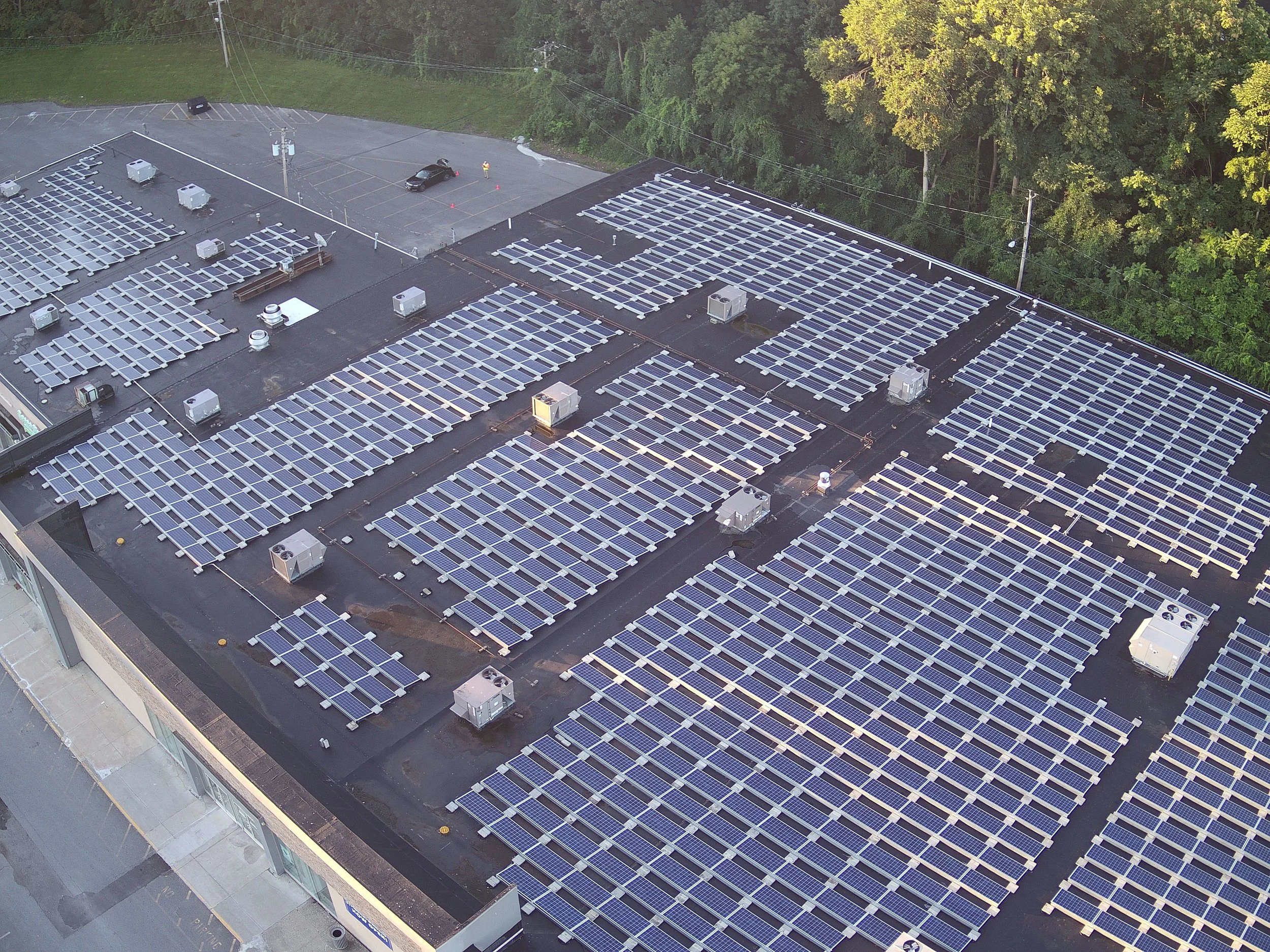
Solar Inspections
Drones provide a fast, accurate, and cost-effective solution for inspecting solar panels, ensuring optimal performance and longevity. Equipped with high-resolution cameras and thermal imaging, drones detect damaged panels, hot spots, dirt buildup, and wiring issues that reduce efficiency. Unlike traditional manual inspections, drones cover large solar farms quickly and safely, minimizing downtime and labor costs.

For annual condition reporting, drones provide comprehensive visual and thermal imaging to assess wear and tear, roofing integrity, and infrastructure stability. This proactive approach enables property managers to schedule maintenance efficiently, extending buildings' lifespans and reducing long-term costs.By improving safety, accuracy, and efficiency, drone construction monitoring enhances decision-making and streamlines operations, making it an invaluable tool for modern property management and construction oversight.

Insurance Inspections
Drones provide fast, accurate, and cost-effective inspections for insurance claims and risk assessments, improving efficiency and reducing fraud.
For damage assessments, drones capture high-resolution aerial imagery of roofs, façades, and properties, identifying storm damage, fire impact, flooding, and structural issues. Thermal imaging detects hidden water damage, insulation problems, and electrical faults, ensuring comprehensive evaluations.
Drones improve safety by eliminating the need for adjusters to climb unstable structures or enter hazardous areas. They also reduce inspection time from days to hours, allowing insurers to process claims faster and minimize delays.

For fraud prevention, drones provide time-stamped, geotagged images, ensuring accurate documentation and reducing fraudulent claims. They also streamline pre-claim property assessments, helping insurers set appropriate premiums.
By cutting labor costs, improving accuracy, and expediting claims processing, drones enhance efficiency, safety, and cost savings, providing a high return on investment for the insurance industry.

Customized, Detailed Reports
AutoCAD, Thermal Roof, Property Condition, Topographic Maps AIA Compatible File Deliverables
By delivering accurate, professional-grade reports, drones enhance project efficiency, improve decision-making, and reduce costs for architects, engineers, and property managers.
Drones streamline data collection by generating customized, detailed reports for construction, real estate, and infrastructure projects. They capture high-resolution imagery, thermal data, and 3D mapping and convert them into actionable insights compatible with industry-standard software.
AutoCAD Integration: Drone-captured data can be processed into CAD-compatible files, allowing engineers and architects to integrate precise measurements into design plans and structural analysis.
Thermal Roof Inspections: Drones with infrared sensors detect heat loss, moisture infiltration, and insulation issues, providing thermal reports for preventive maintenance and energy efficiency.
Property Condition Assessments: Aerial inspections document site conditions, structural integrity, and maintenance needs, streamlining property management and compliance reporting.
Topographic Maps & AIA-Compatible Files: High-resolution mapping and LiDAR-generated terrain models assist in land surveying, site planning, and environmental assessments.